


TANET LAC VERT

surceneux
User
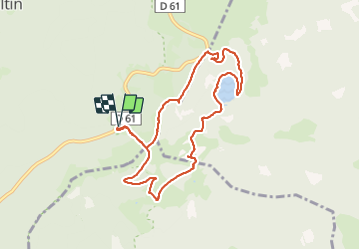

Length
8.7 km

Max alt
1281 m

Uphill gradient
334 m
Km-Effort
13.1 km

Min alt
1053 m

Downhill gradient
333 m
Boucle
Yes
Creation date :
2021-05-28 12:38:45.62
Updated on :
2021-05-28 19:35:28.162
2h30
Difficulty : Medium

FREE GPS app for hiking
 SityTrail
IGN / Geographical institutes
SityTrail Plus
The world is yours!
About
Trail Walking of 8.7 km to be discovered at Grand Est, Vosges, Le Valtin. This trail is proposed by surceneux.
Description
SCHUPFEREN SEESTAEDLE LAC VERT TOUR DREIECK ROCHE TANET
Positioning
Country:
France
Region :
Grand Est
Department/Province :
Vosges
Municipality :
Le Valtin
Location:
Unknown
Start:(Dec)
Start:(UTM)
354448 ; 5327513 (32U) N.
Comments
on a fait l itinéraire dans l autre sens superbe modification du trajet de retour. bon balisage